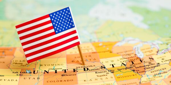
USA Map With States, Capitals And Abbreviations: Traveler’s Guide
The USA Map is more than just geography; it’s a travel planning essential. The United States is a vast country with world-famous attractions, a varied climate, and strict laws and regulations.
If you’re arriving from abroad, whether for a short visit, studying in a U.S. university, or planning a cross-country road trip, knowing the state names, abbreviations, capitals, borders, rivers, and lakes will help you:
- Plan your itinerary across multiple states.
- Identify which states border Mexico, Canada, and coastal areas such as the Bahamas.
- Avoid mistakes when filling in visa forms, addresses, or insurance documents.
- Navigate more confidently between regions.
This guide provides a USA Map overview, a comprehensive table of states with capitals and abbreviations, and offers valuable insights for travel and study.
The United States of America has 50 states. In addition to the 50 states, the U.S. also has:
- 1 federal district: Washington, D.C. (the nation’s capital, not a state).
- 5 major territories: Puerto Rico, Guam, U.S. Virgin Islands, American Samoa, and Northern Mariana Islands.
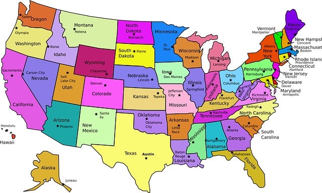
USA Map Overview
A Modern USA Map Typically Displays:
- Borders: state and international boundaries.
- State names and abbreviations: used in travel documents and data records.
- Capitals: crucial for visa paperwork and state-level services.
- Geographic features: major rivers, lakes, and coastal areas.
- Colors: maps often use different colors to highlight distinct state areas.
Note: Always use official USPS two-letter state codes in documents and accounts. Using older abbreviations is a common error that can delay travel or cause data mistakes.
Complete List Of U.S. States With Abbreviations, And Capitals
| State / D.C. | Abbreviation | Capital City |
|---|---|---|
| Alabama | AL | Montgomery |
| Alaska | AK | Juneau |
| Arizona | AZ | Phoenix |
| Arkansas | AR | Little Rock |
| California | CA | Sacramento |
| Colorado | CO | Denver |
| Connecticut | CT | Hartford |
| Delaware | DE | Dover |
| Florida | FL | Tallahassee |
| Georgia | GA | Atlanta |
| Hawaii | HI | Honolulu |
| Idaho | ID | Boise |
| Illinois | IL | Springfield |
| Indiana | IN | Indianapolis |
| Iowa | IA | Des Moines |
| Kansas | KS | Topeka |
| Kentucky | KY | Frankfort |
| Louisiana | LA | Baton Rouge |
| Maine | ME | Augusta |
| Maryland | MD | Annapolis |
| Massachusetts | MA | Boston |
| Michigan | MI | Lansing |
| Minnesota | MN | St. Paul |
| Mississippi | MS | Jackson |
| Missouri | MO | Jefferson City |
| Montana | MT | Helena |
| Nebraska | NE | Lincoln |
| Nevada | NV | Carson City |
| New Hampshire | NH | Concord |
| New Jersey | NJ | Trenton |
| New Mexico | NM | Santa Fe |
| New York | NY | Albany |
| North Carolina | NC | Raleigh |
| North Dakota | ND | Bismarck |
| Ohio | OH | Columbus |
| Oklahoma | OK | Oklahoma City |
| Oregon | OR | Salem |
| Pennsylvania | PA | Harrisburg |
| Rhode Island | RI | Providence |
| South Carolina | SC | Columbia |
| South Dakota | SD | Pierre |
| Tennessee | TN | Nashville |
| Texas | TX | Austin |
| Utah | UT | Salt Lake City |
| Vermont | VT | Montpelier |
| Virginia | VA | Richmond |
| Washington | WA | Olympia |
| West Virginia | WV | Charleston |
| Wisconsin | WI | Madison |
| Wyoming | WY | Cheyenne |
| Washington, D.C. | DC | — |
Complete List Of U.S. States With International Airports
| Abbreviation | State / D.C | Major International Airport(s) | IATA Code(s) |
|---|---|---|---|
| AL | Alabama | Birmingham–Shuttlesworth International | BHM |
| AK | Alaska | Ted Stevens Anchorage International | ANC |
| AZ | Arizona | Phoenix Sky Harbor International | PHX |
| AR | Arkansas | Bill & Hillary Clinton National (Little Rock) | LIT |
| CA | California | Los Angeles Intl, San Francisco Intl, San Diego Intl, Oakland Intl | LAX, SFO, SAN, OAK |
| CO | Colorado | Denver International | DEN |
| CT | Connecticut | Bradley International (Hartford/Springfield) | BDL |
| DE | Delaware | Wilmington Airport (limited international service) | ILG |
| FL | Florida | Miami Intl, Orlando Intl, Fort Lauderdale Intl, Tampa Intl | MIA, MCO, FLL, TPA |
| GA | Georgia | Hartsfield–Jackson Atlanta International | ATL |
| HI | Hawaii | Daniel K. Inouye International (Honolulu) | HNL |
| ID | Idaho | Boise Airport (limited international service) | BOI |
| IL | Illinois | Chicago O’Hare International | ORD |
| IN | Indiana | Indianapolis International(limited international (Mexico/Canada charters), mainly domestic) | IND |
| KY | Kentucky | Cincinnati/Northern Kentucky International(passenger intl service is minimal) | CVG |
| LA | Louisiana | Louis Armstrong New Orleans International | MSY |
| ME | Maine | Portland International Jetport | PWM |
| MD | Maryland | Baltimore/Washington International | BWI |
| MA | Massachusetts | Boston Logan International | BOS |
| MI | Michigan | Detroit Metropolitan Wayne County | DTW |
| MN | Minnesota | Minneapolis–Saint Paul International | MSP |
| MS | Mississippi | Jackson–Medgar Wiley Evers International | JAN |
| MO | Missouri | St. Louis Lambert Intl, Kansas City Intl | STL, MCI |
| MT | Montana | Bozeman Yellowstone International (rare chartered international flights) | BZN |
| NE | Nebraska | Eppley Airfield (Omaha) | OMA |
| NV | Nevada | Harry Reid International (Las Vegas) | LAS |
| NH | New Hampshire | Manchester–Boston Regional (limited intl flights) | MHT |
| NJ | New Jersey | Newark Liberty International | EWR |
| NM | New Mexico | Albuquerque International Sunport | ABQ |
| NY | New York | JFK International, LaGuardia (limited intl), Buffalo Niagara Intl | JFK, LGA, BUF |
| NC | North Carolina | Charlotte Douglas Intl, Raleigh–Durham Intl | CLT, RDU |
| OH | Ohio | Cleveland Hopkins International | CLE |
| OK | Oklahoma | Will Rogers World Airport | OKC |
| OR | Oregon | Portland International | PDX |
| PA | Pennsylvania | Philadelphia Intl, Pittsburgh Intl | PHL, PIT |
| RI | Rhode Island | T.F. Green International(limited international service, mostly seasonal) | PVD |
| SC | South Carolina | Charleston Intl, Greenville–Spartanburg Intl | CHS, GSP |
| SD | South Dakota | Sioux Falls Regional (Joe Foss Field) (rare chartered international flights) | FSD |
| TN | Tennessee | Nashville Intl, Memphis Intl | BNA, MEM |
| TX | Texas | Dallas/Fort Worth Intl, George Bush Intercontinental (Houston), Austin–Bergstrom Intl | DFW, IAH, AUS |
| UT | Utah | Salt Lake City International | SLC |
| VT | Vermont | Burlington International | BTV |
| VA | Virginia | Washington Dulles Intl, Norfolk Intl | IAD, ORF |
| WA | Washington | Seattle–Tacoma Intl, Spokane Intl | SEA, GEG |
| WV | West Virginia | Yeager Airport (limited international service) | CRW |
| WI | Wisconsin | Milwaukee Mitchell International | MKE |
| WY | Wyoming | Jackson Hole Airport (international flights via Canada) | JAC |
| DC | Washington, D.C. | Washington Dulles Intl, Ronald Reagan Washington National (limited intl) | IAD, DCA |
✅ Observations:
- States with full-fledged international airports: Examples:
- AL: Birmingham (BHM) ✅
- AK: Anchorage (ANC) ✅
- CA: LAX, SFO, SAN, OAK ✅
- FL: MIA, MCO, FLL, TPA ✅
- IL: ORD ✅
- NY: JFK, BUF ✅
- TX: DFW, IAH, AUS ✅
- States with “limited international service”: Some airports that mainly handle seasonal or chartered international flights:
- DE: Wilmington (ILG) ✅ – mostly limited/cross-border flights
- ID: Boise (BOI) – very limited international destinations, usually Canada ✅
- NH: Manchester–Boston Regional (MHT) ✅ – very few intl flights
- WV: Yeager (CRW) – limited international flights, mostly seasonal ✅
- Airports with international connections via Canada:
- WY: Jackson Hole (JAC) – no direct scheduled international flights, connections via Canada ✅
Geography Features On The USA Map
When viewing a USA Map, international travelers should note:
- Borders:
- South: California, Arizona, New Mexico, and Texas border Mexico.
- North: Washington, Montana, North Dakota, and others connect to Canada.
- East: Florida lies close to the Bahamas and the Caribbean.
- Rivers: The Mississippi, Missouri, and Colorado rivers have shaped U.S. development and travel routes.
- Lakes: The Great Lakes region (Michigan, Wisconsin, Ohio, New York) is a hub of tourism and trade.
- Colors & Areas: Political maps use different colors to make states easier to identify at a glance.
Top 10 Most Visited States On The USA Map
For international travelers, these states are the most popular destinations:
- California (CA) – Beaches, Hollywood, national parks, and a border with Mexico.
- Florida (FL) – Disney World, Miami beaches, and Caribbean access.
- New York (NY) – NYC landmarks and cultural attractions.
- Texas (TX) – Diverse cities, the Mexico border, and large open areas.
- Nevada (NV) – Las Vegas and desert landscapes.
- Hawaii (HI) – Island paradise, beaches, and volcanoes.
- Illinois (IL) – Chicago, museums, and a central location.
- Washington (WA) – Seattle, the Canadian border, and coastal areas.
- Arizona (AZ) – Grand Canyon and desert scenery.
- Massachusetts (MA) – Boston, a history and education hub.
Tip: When creating a travel plan, continue by linking these states together based on proximity and flight routes.
Common Mistakes Travelers Make With State Names & Abbreviations
- Washington vs. Washington, D.C.: WA is a state; D.C. is the capital city of the country.
- Using old names: Calif. instead of CA, Penna. instead of PA.
- Nebraska error: Always NE, never NB.
- Copy-paste errors in forms: Check travel files before you share them.
- Time zone confusion: Capitals and states may be in different zones; always check the time when booking.
How To Use The USA Map For Travel Planning
- Create itineraries with state names, abbreviations, and capitals.
- Check borders to continue journeys across Canada or Mexico.
- Use official abbreviations in visas, insurance, and airline accounts.
- Work with maps digitally: most maps are stored as images or PDF files, easy to open, copy, or share.
- Classroom learning – Teachers use the USA Map to display rivers, lakes, and capitals for students.
Historical Development Of USA State Abbreviations
- Before 1963: Long-form abbreviations like Calif. and Penna. were common.
- 1963: USPS standardized two-letter codes for mail and stored them in official data systems.
- 1969: Nebraska switched from NB to NE to remove confusion with Canada.
- Today: These codes are used across visa forms, travel documents, and government terms worldwide.
Interactive Map Of USA: Digital Tools And Resources
Interactive maps have become an essential tool for anyone looking to understand the complex geography of the USA,
offering a dynamic way to explore different states and regions. With the ability to click, zoom, and change the display,
users can engage with the map in a more meaningful way.
Online Interactive Map Platforms
Several online platforms offer interactive maps of the USA,
providing a range of features such as the ability to copy and remove layers, change colors, and explore specific areas in detail.
These platforms are invaluable for educational purposes and for anyone looking to delve deeper into US geography.
| Platform | Features | Accessibility |
| Google Maps | Street View, Satellite Imagery, Real-time Traffic | Web, Mobile App |
| MapQuest | Route Planning, Traffic Updates, Points of Interest | Web, Mobile App |
| USGS Maps | Topographic Maps, Geographic Information | Web |
Mobile Apps For USA Geography
Mobile apps have made it easier than ever to explore the USA on the go. Apps like “USA Map Quiz” and “GeoGuessr”
offer interactive games and quizzes that can help users learn state capitals, boundaries, and other geographical features.
Educational Games And Quizzes
Educational games and quizzes are a fun and engaging way to learn about the USA.
By continuing to challenge oneself, users can improve their knowledge and retention
of geographical information.
Printable USA Maps And Resources
For those who prefer a more traditional approach, printable USA maps are available online.
These resources allow users to change and customize the maps to suit their needs,
such as highlighting specific areas or copying maps for educational purposes.
Conclusion: Why Every Traveler Needs A USA Map
The USA Map is not just an image; it’s a navigation and planning tool. By knowing state names, capitals, and abbreviations, international travelers can:
- Avoid mistakes in documents.
- Plan routes across rivers, lakes, and borders.
- Continue trips smoothly across states and regions.
From California’s Pacific coast to Utah’s national parks, and Washington’s Canadian border to Florida’s gateway to the Bahamas, the USA offers vast and diverse areas to explore.
Before your journey, remember to protect your time in the country with travel insurance to ensure peace of mind wherever the USA Map takes you.
Frequently Asked Questions (FAQ)
How many states are in the USA?
The United States has 50 states. In addition, it includes Washington, D.C. (the federal district) and five major territories: Puerto Rico, Guam, American Samoa, the U.S. Virgin Islands, and the Northern Mariana Islands.
What is the capital of the USA?
The capital of the United States is Washington, D.C. (District of Columbia). It is not part of any state.
Which state is the largest in the USA?
The largest state by area is Alaska. It is nearly twice the size of Texas, the second-largest state.
Which state is the smallest in the USA?
The smallest state by area is Rhode Island. Despite its size, it has a high population density.
Which states border Mexico?
Four U.S. states share a border with Mexico:
- California (CA)
- Arizona (AZ)
- New Mexico (NM)
- Texas (TX)
Which states border Canada?
Thirteen U.S. states border Canada, including Washington, Montana, North Dakota, Minnesota, Michigan, New York, Vermont, Maine, and several others.
What are the Great Lakes states?
The states around the Great Lakes are Minnesota, Wisconsin, Illinois, Indiana, Michigan, Ohio, Pennsylvania, and New York.
Which state has the most population?
California (CA) is the most populous state, with over 39 million residents.
Which state has the least population?
Wyoming (WY) has the smallest population, with fewer than 600,000 people.
How many time zones are in the USA?
The U.S. has six primary time zones: Eastern, Central, Mountain, Pacific, Alaska, and Hawaii–Aleutian. If territories are included, the number rises to 11 time zones.